A new open-source project uses British historical maps to reveal what Palestine looked like before 1948.

The Palestinians recently protesting in the Gaza Strip called their demonstration “The Great Return March”—that’s a reference to a desire to return to the land from which they were expelled in 1948. Of the 1.9 million Palestinians living in Gaza, 70 percent came from villages in the surrounding area and beyond, in what is now Israel, 70 years ago this month.
During the founding of the state, the Israeli military destroyed more than 500 Palestinian villages; some were completely abandoned, while others became the foundation for Jewish villages and towns. Some villages survived. A new open-source mapping project, Palestine Open Maps, allows users to see the Palestinian landscape as it looked before 1948—and to search for villages and towns from that era to find out whether they remain, were depopulated, or were built over.

A screenshot from the project showing how users can discover what happened to Palestinian villages mapped by the British in the 1940s. (Courtesy of Palestine Open Maps)
Such a project is not entirely new. The Israeli nonprofit Zochrot, for example, has mapped destroyed Palestinian villages. But Palestine Open Maps is the first open-source mapping project based around historical maps from the British Mandate period, which preceded the creation of the state of Israel. Though the British map sheets were already available online and in the public domain, they were difficult to obtain in high resolution and were divided into hundreds of separate sheets, so it wasn’t possible to visualize them as a whole.
Ahmad Barclay, a Beirut-based architect and designer who led the project—which was initiated through a collaboration between the organization Visualizing Palestine and Columbia University Studio X Amman—said the team knitted together more than 200 map sheets and made them navigable in high resolution. (Disclosure: I now work as the managing director of Al-Shabaka, The Palestinian Policy Network, a think tank.)
The maps’ level of detail is exceptional, showing roads, topographic features, and property boundaries. The team’s next task: to make the maps downloadable.
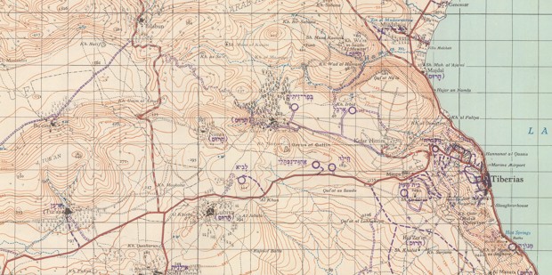
The project also features Israeli overprints of the British maps, like this 1958 one of the city of Tiberias and its environs, marking destruction of Palestinian villages and the new Jewish-Israeli settlements built on their lands. (Courtesy of Palestine Open Maps)
In the decades since 1948, what Palestinians call the nakba (“catastrophe”) remains a matter of debate between the sides of the Israeli-Palestinian conflict. For Barclay, an aim of the mapping project is to clarify at least one part of this debate: the land itself, and what was once there. “Putting the villages on screen that were destroyed, depopulated, and built over in the form of these maps makes what happened irrefutable,” he said. He also noted the irony of using the maps of the former colonizer for such a project. “The British essentially drew these maps as part of their control of Palestine,” he said. “But the maps unintentionally captured the moment before the destruction occurred.”
He also pointed out a potential future use for the project: backing the property claims of Palestinians, should they be able to return to the land from which their parents and grandparents came. “These maps can show the villages from which protesters originated,” said Barclay.
Original Article
https://www.citylab.com/life/2018/05/mapping-palestine-before-israel/560696/
0 comments:
Post a Comment
Please type your comment, Note that comments are monitored and no Zionists are allowed.